English Spanish

Rain Forest

Map with colored areas showing locations of 4 ACG ecosystems (marine, dry forest, cloud forest, rain forest)
Fig. 1.  General distribution of the three terrestrial ACG ecosystems – dry forest (yellow), upper elevation cloud forest (blue), and rain forest (green). The Pacific coastal dry forest extends from the inland side of the coastal dunes and mangroves (with their roots in saltwater and brackish water) eastward across the coastal plain and up to about 400-500 m elevation on the Pacific side of the Cordillera Guanacaste, where it blurs into the Caribbean rain forest that wraps around the middle elevations of the Cordillera. The latter results in many so-called Caribbean rain forest species being actually found in Guanacaste Province, which is generally thought of as a dry forest province. The blue cloud forest on the Cordillera upper elevations is rapidly shrinking as climate change comes on and the generally hot and dry lowland air mass slides up the volcanoes. Map: Waldy Medina, ACG.

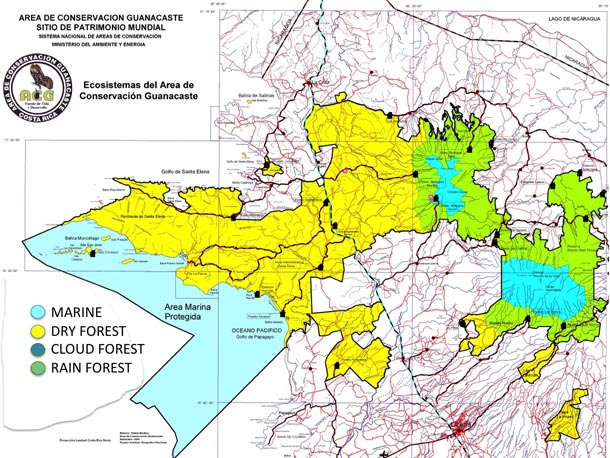
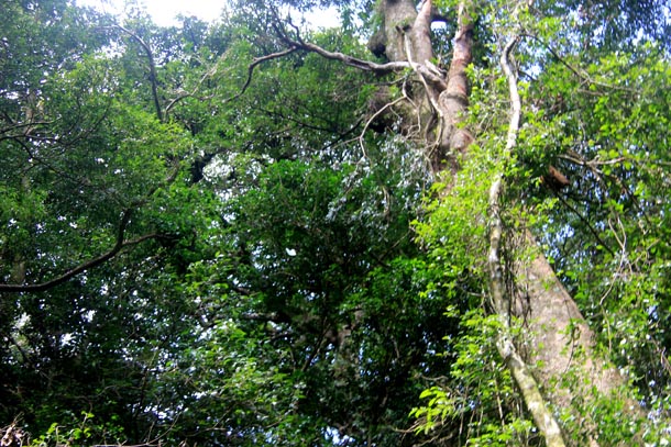
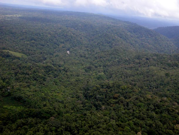
ACG rain forest, green in ACG’s primary ecosystem map, occupies the bulk of the northeastern side of ACG, from about 90 to 1000 m elevation. It goes no lower in elevation because the yet lower northern and eastern terrain is almost entirely intensely farmed agroscape (oranges, pineapple, subsistence farming, palm heart, pasture, etc.). While these lands could be restored over decades (through expansion of ACG) to a semblance of the forest that once grew there 50-150 years ago, such agroscape is way too expensive to purchase today, given the presence of a few other lower-elevation conserved wildlands more to the east in Costa Rica. However, it should be noted that the ACG rain forest on the Caribbean slopes is the last large conserved remnant of the lowland rain forests that once extended from ACG to the Caribbean coast, and therefore is indeed a tiny island with all the attendant problems that come with insularization.

Cattle and some remnant forest trees in large pasture; forest still standing in the background

Freshly plowed red dirt in field where old orange trees ripped out, ready for replanting

Large orchard of orange trees; forest and Volcan Orosi of ACG in distance

Fig. 2. The boundary agroscape that surrounds the ACG island of conserved wildlands. These biodiversity-destitute habitats extend right up to the ACG wildland boundary, and are one of the many fates expected for any parcels not explicitly protected as conserved wildland.  Such terrain can be restored to rain forest by allowing natural invasion from neighboring intact forest, but it takes centuries to re-create something approximating the original vegetation. As it is, it contains much less than 1% of its original biodiversity. 2A. Closely grazed African grass pasture on the eastern side of Volcán Cacao (center), pasture that was 30-40 m tall dense rain forest 50-100 years ago, between Dos Ríos and San Luis (28 March 2010). 2B. Newly cleared secondary rain forest for new orange plantation on east boundary of Sector Rincón Rain Forest, near Birmania (2 November 2008). 2C. 15-year-old Del Oro orange plantations filling the space between the La Cruz-Santa Cecilia highway and ACG Sector Del Oro rain forest. Volcán Orosi (right) and Orosilito (left) in background, with cloud forest remnants on their tops (2010).

ACG rain forest is more narrowly termed “mid-elevation rain forest” and supports the high level of biodiversity characteristic of tropical intermediate elevation rain forest — which, in Costa Rica, is the most species-rich of all Costa Rican terrestrial ecosystems. In general terms, 2-10 times as many species live and circulate through a hectare of ACG rain forest as through a hectare of ACG dry forest. However, since almost all of ACG dry forest is in some stage of restoration following severe anthropogenic perturbation, it remains to be seen centuries from now how this comparison will eventually play out.

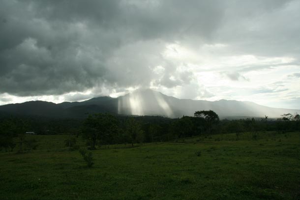
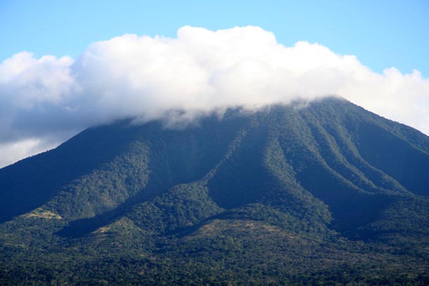
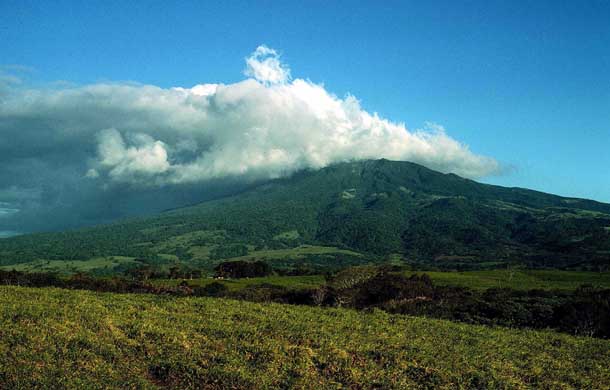
In general terms, ACG intermediate elevation rain forest is largely the product of the moisture-laden trade winds blowing from the Caribbean to the Pacific Ocean and rising when they hit the Cordillera Guanacaste to cool and drop their water as rain, fog and mist. These slopes also receive the full brunt of Caribbean hurricanes moving westward. For a given site, the total annual rainfall ranges between about 2000 and 4000 mm, but this total varies strongly among years at each site. There is a distinct “drier” time of year (January through May), but there always has been enough water falling and frequently enough that most streams and all rivers are ever-flowing, and the soil remains moist, even if the litter dries out somewhat during the lightly emphasized dry season. Many animals and plants in ACG rain forest display strong calendar-defined phenological patterns, though it is not immediately obvious how such synchrony and dormancy-active patterns are cued.

Volcan Cacao seen from the east with forest wrapping all around it, under heavy rain clouds

Fig. 3. Localized rainfall on the eastern slopes of Volcán Cacao from the orographically uplifted clouds generated when the trade winds hit the Cordillera Guanacaste as they blow from northeast to southwest through ACG.  This rain generates the Caribbean rain forest and cloud forest ecosystems of the eastern portion of ACG (14 June 2009).

Eastern side of Volcan Rincon, large forest Ceiba tree isolated in second growth, in mist and rain

Fig. 4.  A normal rainy season day at ACG Estación Caribe (415 m) in central Sector Rincón Rain Forest. The isolated Ceiba pentandra (Malvaceae) tree behind the station is 45 m tall and would have been slightly emergent in the original rain forest at this site. Today, it is surrounded by young secondary forest in what was open pasture 20 years before. While it is in full leaf, its crown is also packed with green epiphytic bromeliads, orchids, ferns and mosses (23 May 2006).

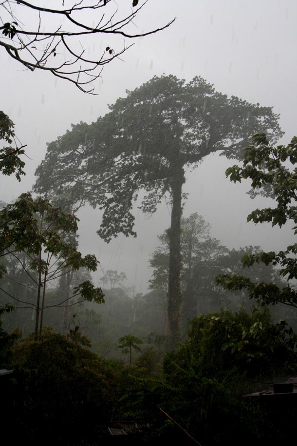
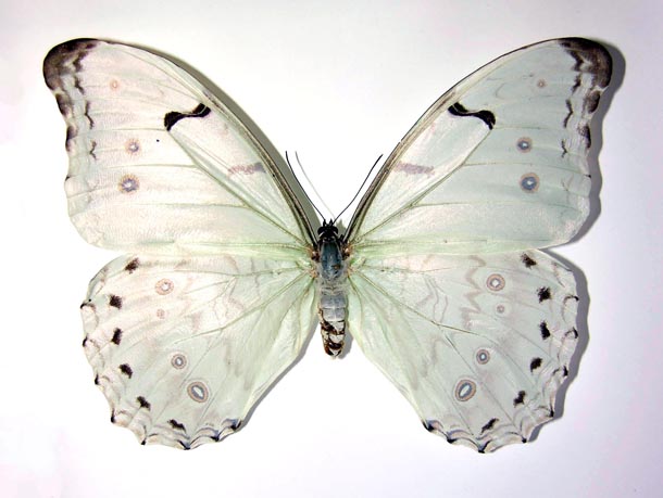
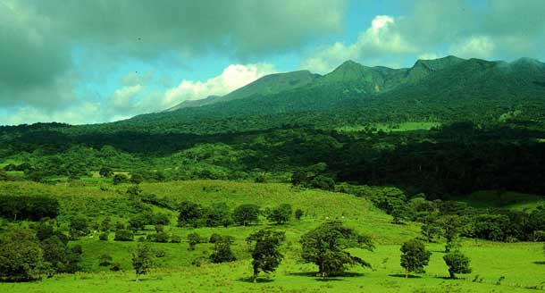
ACG mid-elevation rain forest differs from that of many other rain forest national parks in that the Caribbean slope rain forest wraps around the isolated volcanoes into an interdigitation with Pacific coastal dry forest, as is evident in the ACG ecosystem map. This has two distinctive outcomes for ACG biodiversity. First, in the extensive overlap zones between these two major ecosystems live many species of insects not found deep into either of the zones. A glaring example is the huge white butterfly Morpho catalina (Nymphalidae) that is endemic not only to Cordillera Guanacaste, but also, apparently, endemic to this intergrade zone on the Pacific-facing slopes between about 700 and 1200 m elevation.

Garish hairy caterpillar of butterfly Morpho catalina

White butterfly with huge white wings, Morpho catalina

Huge white butterfly flying high in rainforest clearing

Fig. 5. Costa Rica’s white morpho, Morpho catalina (Nymphalidae), is endemic to Cordillera Guanacaste (though we do not understand why it is not also found throughout other Costa Rican upper elevation mountains). This species is among the very largest of the day-flying butterflies in ACG. Its caterpillars (5A) feed on Inga (Fabaceae) and a few other plants in the deeply shaded understory of ACG mid-elevation rain forest (just below the cloud forest) on the Pacific slopes of the Cordillera. Apparently owing to the deep shade, their food is of such low nutritional value that, combined with the continually cool-cold forest understory, they have an incredibly slow development time. The eggs are laid in late August and September, and the caterpillar is not full-sized until 7-8 months later in March-April, to pupate in May-June, and the adult emerges at last in late July and early August. The huge white adults (5B) have a look-alike in Honduras and in dryland western Mexico, both of which are other similar species, despite the fact that in older literature all three have been known as Morpho polyphemus. When flying high in the forest (5C, center; 29 August 2012) they look like sheets of flying white paper and are extremely difficult to approach unless trapped with a butterfly trap baited with fermenting bananas (Isidro Chacon, personal communication). 

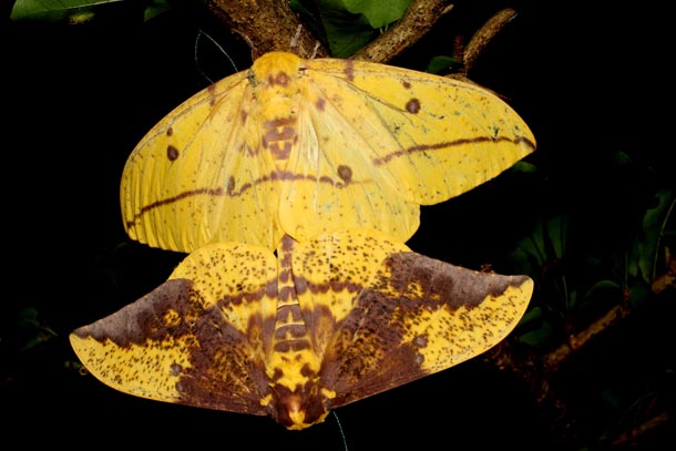
Second, distinctive species of both ecosystems can be found growing within a few meters of each other. For example, the big-fruited Manilkara zapota (Sapotaceae) rain forest trees occur side by side with the small-fruited Manilkara chicle dry forest trees in the remnant forest peninsulas on the north slopes of Volcán Orosi. Equally, the introduced dry forest big-fruited Enterolobium cyclocarpum (Fabaceae), or guanacaste tree, occurs side by side with the rain forest small-fruited Enterolobium schomburgkii at Estación Los Almendros in Sector El Hacha. The rain forest large yellow moth Eacles imperialisDHJ01 (Saturniidae) can be collected in the same trap baited with a virgin female as its dry forest look-alike Eacles imperialisDHJ02 at Estación Gongora in Sector Cacao (and they differ by 8% of their DNA barcodes).

2 mating moths, colored deep yellow and purple, of Eacles imperialis

Fig. 6. Mating female (upper) and male (lower) of Eacles imperialisDHJ02 (Saturniidae) moths at Estación Santa Rosa, Sector Santa Rosa, ACG (14 August 2011). In this case, both individuals are dry forest species, but they differ by 8% of their DNA barcodes from the ACG rain forest look-alike Eacles imperialisDHJ01. If the female had been put out in the ACG rain forest to mate, a male Eacles imperialisDHJ01 would have happily mated with her and their offspring would appear to be perfectly normal. How it is that they are still unambiguously two different species is too complex to explain here, but is an entry point to understanding that tropical species biodiversity is much more complex than is generally appreciated. (Note: Eacles imperialisDHJ01 and E. imperialisDHJ02 are informal names for recently-discovered cryptic species awaiting formal naming, and so their names are not written in italics.)

A pragmatic scientifically painful outcome of this interdigitation of two major ecosystems is that a specimen cannot be placed ecologically by place names, such as Guanacaste Province (thought of as “dry forest”) and Alajuela Province (thought of as “rain forest”). And (heavily rain-forested) Guanacaste Province even wraps around the north side of Volcán Orosi well into the rain forest of the Caribbean slope.

A single forested volcano, Volcan Orosi, with steep rugged slopes, topped with a white cloud that is large and dark gray to the left (east) and thin and fluffy white to the right (west)

A sprawling forested volcano, Rincon, from afar topped with clouds in a blue sky. On the left (east side) the clouds are thick and dark, on the right they vanish into wisps in a blue sky

View of Caribbean side of Volcan Rincon massif, covered in forest, seen from lowland pasture

Fig. 7.  The ACG cloud forest ecosystem is perched high on the tops and upper slopes of the Cordillera Guanacaste, merging below with mid-elevation rain forest. This is the ecosystem that is gradually being burned off the tops of the volcanoes by the heating/rising of the lowland warm air mass, a climate change event that will extinguish or greatly alter the species currently occupying these wet and cold “islands in the sky”. There is no place for their species to move to, and worse, the lowland predators and parasites are moving up the mountains along with the warmer air, thereby subjecting the mountain tops to biological challenges not known before by them. 7A is Volcán Orosi, extending to about 1400 m, as viewed from the north. Its lower foothills are scarred by old pastures and fields that were in place before they were obtained through a land trade with the Del Oro orange plantations, just out of sight at the bottom of the image. This late afternoon photo was taken at the beginning of the long dry season with cloudless skies developing over Guanacaste Province to the right (12 January 2008). 7B is Volcán Rincón de la Vieja seen from the north, extending to about 1900 m here. Dry forest and rain forest blur together on this slope, and this is the only flank of this volcanic complex not protected by being fully inside the ACG. This dry season photo again shows the blue skies of Guanacaste Province dry forest to the right, and Caribbean rain forest clouds to the left, clouds hovering over Estación Caribe and Estación San Gerardo (10 March 1999). 7C is the northern end of Sector Rincón Rain Forest, under the heavy clouds to the left of 7B. These pastures were outside of ACG (but are now being restored to rain forest in ACG’s Sector San Cristobal) and the uppermost slopes are the old Parque Nacional Rincón de la Vieja, with Sector Rincón Rain Forest being the forested slope between the pastures and the uppermost slopes (18 July 1993).

ACG is fortunate in having been able to acquire the last remaining block of about 2,000 ha of this relatively intact old growth rain forest, the center portion of Sector Rincón Rain Forest (thank you, Wege Foundation and Blue Moon Fund).  It is centered on the canyon of the Río Cucaracho, which carries major stream flows off of Volcán Rincón de la Vieja and Volcán Cacao into its confluence with the Río Pizote, and then into Lake Nicaragua.

Mosaic of old forest, second growth forest and pasture on the slopes of a river valley and mesa above

Forest of tall trees, with a person who is dwarfed by the height of the tree trunk

Fig. 8. 8A. Aerial view from south to north along the long axis of Sector Rincón Rain Forest. The plane is over the eastern foothills of Volcán Rincón de la Vieja, and the primary-rain forest-lined valley contains the Río Cucaracho flowing off of the same volcano. This forest has been added to ACG since 2008 and is still being constructed at its most northern end (September 2013); this is the photograph that set off the entire effort to find and purchase these 3,000 hectares (photo Waldy Medina, 20 August 2007).  8B. The primary, old-growth, forest interior beneath the rain forest canopy in 8A. 100+ years ago, all of the fields and pastures of this part of Costa Rica were covered with 30-40-m tall forest (and deep shade) of this nature, but never again will that be the case (20 May 2008).

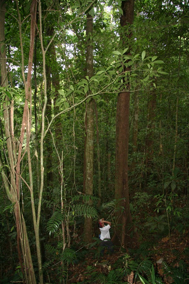
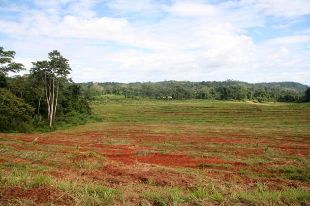
However, most of ACG rain forest is a fine scale mosaic of old growth rain forest, selectively logged patches (which contributed most of the roads in this zone), and abandoned subsistence farms that operated for only 2-4 decades. Fortunately, the Caribbean slope of ACG was strongly inaccessible, far from centers of populations and political power, and not possessed of a soil/climate interaction that leads to high quality agriculture. Today, all of these perturbed areas are rapidly restoring into variously aged forest, although it will take 100-300 years before it approximates an unbroken rain forest ecosystem. Owing to climate change and insularization (natural boundary on the uphill side, agroscape boundary on the downhill side), whatever form it finally takes will only approximate the original.

At present, it is a fair guess that the ACG rain forest is home to at least 250,000+ species of organisms, though it is unclear what toll insularization by the agroscape will take on these populations; by itself, 30,000-40,000 ha is certainly not large enough to sustain all its original species, and that in turn is broken into various habitats and subecosystems, each represented by only much small areas than those that they once occupied along the entire Caribbean slope of the mountain range extending from Volcán Orosi all the way to Panama. However, GDFCF and ACG are steadily "re-aggregating" small properties through willing-seller negotiations to form a larger block of protected rain forest, one that is now well over 30,000 ha in size and growing incrementally.

Moths and butterflies of many sizes, colors, and shapes, pinned and tightly shingled in a box

Fig. 9. A small sample of the butterflies and moths that wing their way through ACG’s Sector Rincón Rain Forest, all reared from caterpillars found by parataxonomists in their daily search as part of the biodiversity inventory. These specimens have been prepared as voucher specimens for their DNA barcodes, and for their eventual permanent homes in the collections at Costa Rica’s Museo Nacional, the National Museum of Natural History at the Smithsonian Institution in Washington, D.C., and other public collections around the world (8 November 2004).

ACG rain forest soils, despite being volcanic in origin, are indeed quite “poor” from the viewpoint of farming/ranching, since they are highly leached of their minerals by the year-round rain and moisture at warm temperatures, and because the continual fungal biodegradation of moist and warm leaf litter blocks carbon accumulation in the soil.

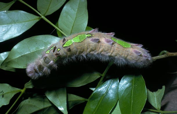
While the biological exploration of ACG rainforest has now had two decades of intense inventory of Lepidoptera (moths and butterflies through their caterpillars) and plants, with occasional forays for vertebrates and very specific invertebrates (fungi, spiders, snails), the taxonomic composition of this ecosystem and its millions of interactions remain tierra incognita.

Purple and white orchid flower from rain foest

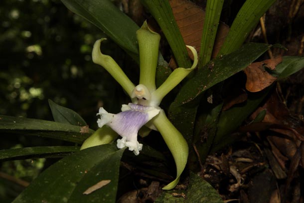
Fig. 10.  The single but very, very fragrant flower of Cochleanthes aromatica, an epiphytic orchid 1.5 m above the ground in secondary rain forest at Estación Leiva in Sector Rincón Rain Forest. While the pollinator is unknown, it is very likely to be a night-flying large moth, perhaps in the family Sphingidae. We found the silver-dollar sized flower by searching for the source of the odor filling many square meters of the rain forest understory  (24 October 2010).

Trail camera photo of 2 pumas (mountain lion) in forest

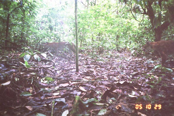
Fig. 11.  Two mountain lions, presumably mother and teenager, captured by a camera trap placed in the forest understory next to Estación Biologica San Gerardo in the ACG’s Sector San Cristobal.  How these shy animals, omnipresent throughout ACG, find enough prey in the rain forest to avoid starvation remains a mystery (photo: Ronit Amit 29 October 2005).

Strange balanophore flower growing out of rainforest soil

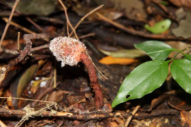
Fig. 12.  The “flower” of the understory obligatory parasitic plant, Balanophoraceae (perhaps the species Helosis cayennensis?), a plant of ACG old-growth undisturbed rain forest, in this case Bosque PreCafetal on the Pacific mid-elevation slopes of Volcán Santa Maria of Cordillera Guanacaste.  This 10 cm tall non-green flowering plant gains all its nutrients from its underground tuberous connection to the roots of its host and no parts of it emerge above the soil until it is ready to flower and fruit (29 August 2012).

Parataxonomist Petrona Rios crossing headwaters of river

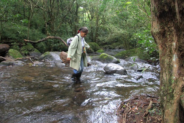
Fig. 13. Petrona Ríos, a veteran parataxonomist, wades gingerly through the crystal clear water flowing from the old-growth forested Bosque Precafetal rain forest on the Pacific slope of Volcán Santa Maria in ACG’s Sector Santa Maria. This water has the distinction of being among the 10+ pesticide-free rivers flowing off the Cordillera Guanacaste, free of pesticides because the clouds that condensed in the cloud forest above to create the river had for the most part dropped their pesticide-laden water on the Atlantic side of the mountains as they rose (29 August 2013).

Bright red spiral fruit of Pithecellobium with shiny black seeds inside

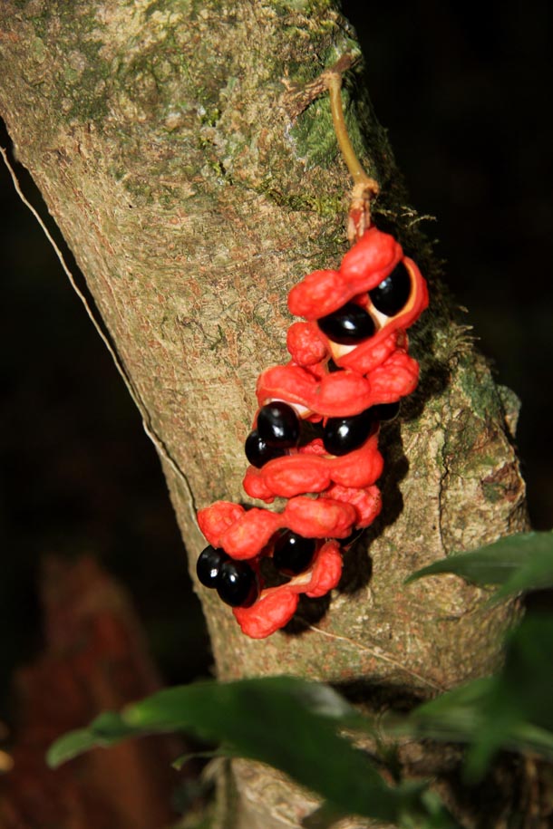
Fig. 14. The bright red cauliflorous fruit of Cojoba costaricensis (Fabaceae) advertises its available fruit in the shady understory of old-growth forested Bosque PreCafetal in ACG’s Sector Santa Maria on the Pacific slopes of Volcán Santa Maria. The bright red fruit has no nutritional value and is not eaten – it is just the flag, indicating the presence of something edible. The real food value is in the black thin aril covering the seeds. When a large bird, such as a toucan or trogon, swallows that seed, its gizzard strips off the aril and the olive-pit-sized seed is then regurgitated (29 August 2012).

Transparent jelly-like substance with red core at base of orange-red mushroom

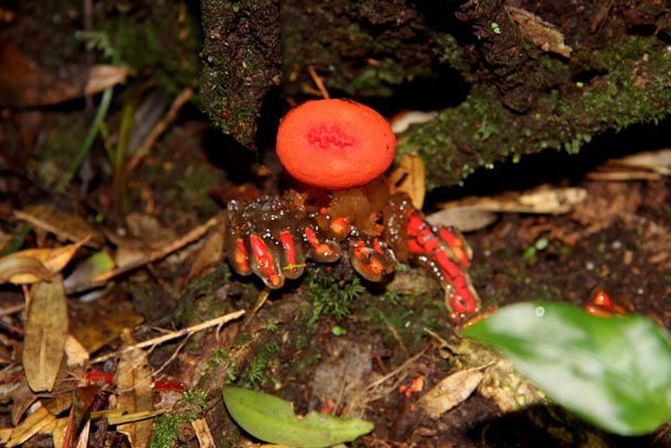
Fig. 15.  A strange fungus on the forest floor of Bosque Precafetal in ACG’s Sector Santa Maria on the Pacific slopes of Volcán Santa Maria. Its biology is unknown, just like that of thousands of other species of things growing and living in this as-yet unexplored forest (29 August 2012).

Deeply imprinted tapir track on muddy trail

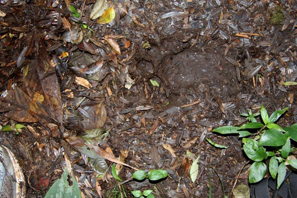
Fig. 16. The track of an adult jaguar hind foot in the muddy trail at mid-elevation Bosque Pre-Cafetal in ACG’s Sector Santa Maria on the Pacific slopes of Volcan Santa Maria. Four large toe-prints and one long and large palm print make this track as large as a human hand. This big cat survives by eating just about anything that moves, and some that does not (29 August 2013).